
Arizona: Grand Canyon and the Red Rock Country
Sedona's vortexes, Antelope Canyon's light, and the Grand Canyon's scale — the American Southwest in its most elemental form
I drove Arizona in October 2017, a road trip that started in Phoenix and moved north through Sedona, the canyon country, and the Navajo Nation, ending at the Grand Canyon South Rim. The route took ten days at a pace that felt right. The Sonoran Desert in October is warm but manageable; the high plateau around the canyon is already cool in the mornings and cold at night.
Arizona's landscape works in layers. The desert in the south — saguaro cactus, red mountain ranges, the grid of Phoenix — is one register. The red rock country around Sedona, the canyon lands near Page, the Grand Canyon itself — these are different registers entirely, each one improbable in its own way.
Sedona and the Red Rocks
Sedona has a reputation for spiritual tourism and vortexes (the local belief that certain sites have energetic concentrations that affect human experience) that predisposes some visitors to dismiss it. Mistake. The red rock formations around Sedona — Cathedral Rock, Bell Rock, the Courthouse Butte — are genuinely extraordinary geological formations, and the hiking through them is some of the best in the Southwest. The vortex thing is optional; the rock formations are not.
Antelope Canyon
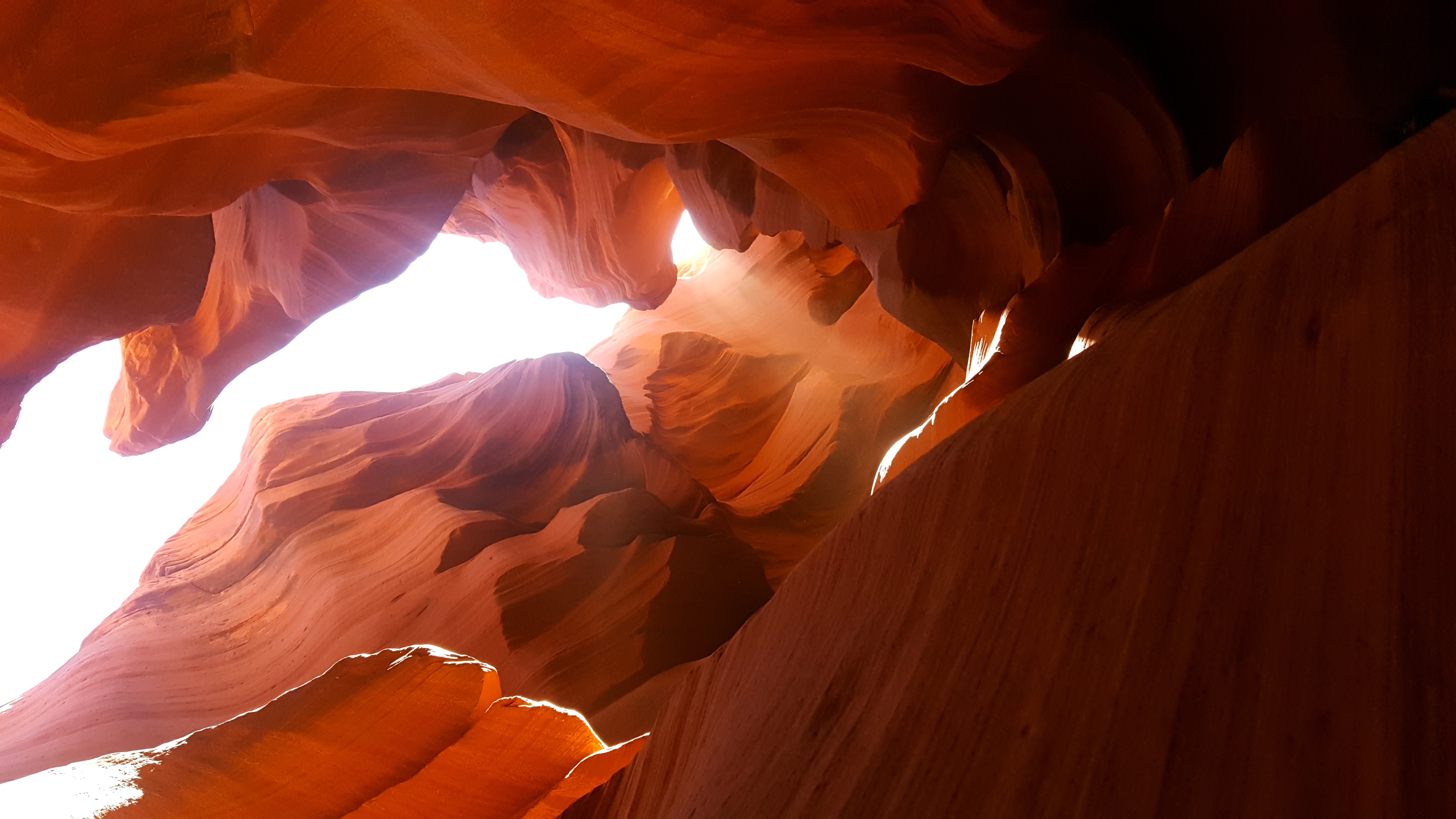
Antelope Canyon near Page is a slot canyon — a narrow, sandstone passage carved by flash floods over millions of years, with walls that taper to a slit at the top and light that enters in vertical beams at midday. It requires a Navajo-guided tour and the midday light tour is worth booking weeks in advance for the shaft-of-light photographs. The canyon is 120 metres long and the walls are in constant motion as the light shifts. It is one of the most photogenic places in the American Southwest and also one of the most genuinely beautiful.
The Grand Canyon
The Grand Canyon South Rim is 277 miles long, up to 18 miles wide, and more than a mile deep. The Colorado River at the bottom is visible as a thin brown thread. The rock layers span two billion years of geological history. None of this is properly processable from the rim. You understand it better on the way down — even the first mile of the Bright Angel Trail gives you the canyon in a different way, the walls closing in, the scale shifting. Going all the way to the river and back in a day is ill-advised (rangers will tell you this repeatedly); going down to the first rest stop is entirely worth the effort.
Arizona


